Tentative Expedition to Kyrgyzstan in 2004
Unfortunately, due to lack of interest, it is now very unlikely that
a trip to these parts will happen.
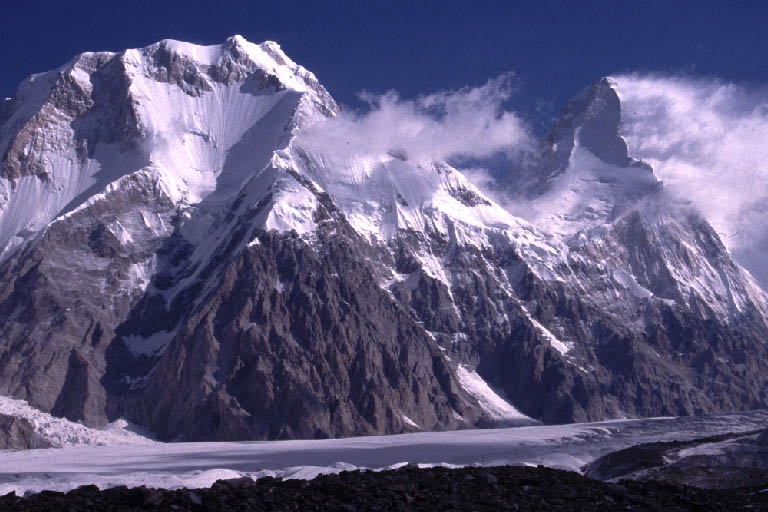
Image 1 - Khan Tengri
Introduction
The mountains of Kyrgyzstan formed the Soviet border with China and led
to visitors being kept out of the country. Kyrgyzstan opened to the
world just over 10 years ago. Hsuan Tsang visited Kyrgyzstan in the
seventh century and warned that travellers would be molested by
Dragons (1).
Kyrgyzstan is about the same size as Great Britain with an altitude range from
401 metres above sea level to 7,437 metres above sea level. 90% of
the territory is above 1,500 metres and 41% is above 3,000 metres.
Kyrgyzstan also has 1,923 lakes taking up 4.3% of the total land area
of the country. The country is also home to one of the largest
glaciers in the world, the Inylchek Glacier in the Central Tien Shan,
which is over 62 kilometres long. (1)
Kyrgyzstan has a large variety of plants, possessing over 1% of all know species
in just 0.13% of the worlds land mass. The lower slopes of the
mountains contain rare Walnut and Pistachio forests in the south and
Juniper and Tien Shan Pine in the north. There is over 360 recorded
species of birds in Kyrgyzstan including a wide range of raptors (1).
The population of Kyrgyzstan on July 2001 was 4,753,003 giving a density
of 24 people per square kilometre; over half of this population lives
in the Fergana Valley (just 15% of the total area of the country).
Useful Information
Getting There
Bishkek airport has recently been renovated and updated. Flights from London
are with British Mediterranean airways and from Manchester with KLM.
Flights from Manchester go via Amsterdam and can cost less than £500
(4).
Visas and Red Tape
Kyrgyzstan is doing more than any other Central Asian country to simplify its
visa system (1). Visas cost £40 for four weeks, and require a
letter of invitation; I have been offered these from the ITMC for $10
admin fee per person.
Trekking Permits are also required for some areas. Travel agents can arrange
this and again I have had an offer from ITMC for organising permits.
Other
|
Languages
|
Kyrgyz and Russian
|
|
Currency
|
Som and US Dollars
|
|
Maps
|
Very hard to find
|
|
Health Service
|
Abysmal
|
|
Food and Drink
|
A lot of Mutton
|
|
Safety
|
Hospitable, tolerant and safe
country
|
|
UK Foreign Office Status
|
No specific threat in Kyrgyzstan
to British Nationals. Some threat from potential terrorist
attack. Advise against travel to South West of Osh and the
Ferghana Valley.
|
|
Capital
|
Bishkek
|
Mountaineering Possibilities
85% of Kyrgyzstan area consists of mountains; they are part of two main
mountain ranges, the Tien Shan and the Pamirs. Three summits are
above 7,000 metres: Pobeda, Khan-Tengri and Lenin.
The Tien Shan is one of the largest mountain ranges in Asia. About 2/3
mountains in the Tien Shan are in Kyrgyzstan. The mountains are
made of Sedimentary, Metamorphic and Igeous rocks.
The climate of the Tien Shan consists of hot summer weather in the
valleys and foothills and cold weather in the ‘Alpine’
zone. Large fluctuations in temperature are common for a day and a
year. The cloudiest time of year is March and April while the least
one is August and September. Most of the annual precipitation falls
during the first part of summer.
Kyrgyzstan covers only the northern area of the Pamirs. The climate of the
Pamirs is similar to the Tien Shan but comparatively stable with less
humidity.
The mountains of the Tien Shan can be split into five areas of interest.
These areas are detailed below, more information can be found on the
ITMC website. Information given here on routes and virgin peaks is
only as up to date as the ITMC website.
Central Tien Shan (Tien Shan)
This area is situated in eastern Kyrgyzstan, at the border with China. This
area contains the Inylchek Glacier (one of the largest in the world).
This area also contains two of the summits above 7,000 metres,
Pobeda and Khan-Tengri. There are 23 summits higher than 6,000
metres and 80 summits 5,000 to 6,000 metres; among these there are 3
virgin peaks 6,000m+ and 14 virgin peaks 5,000m – 6,000m.
About 70 mountaineering routes have been completed in this area, with
predictably a lot of these being on the 7,000 metre peaks (21 on
Khan-Tengri and 8 on Pobeda).
The area around the south of the Inylchek Glacier is one of the most severe in
Kyrgyzstan. Weather conditions vary rapidly with bad weather staying
for many days. Typically one or two days are required for snow to
settle. Routes are mixed snow and ice.
There are two stationary base camps in this area that are now run by the ITMC.
Both camps are on the slopes below Peak Gorkii. Helicopters operate
regularly to these base camps. Without the use of helicopters ‘walk
ins’ are several days.
Kaindy Glacier is situated to the south west of the Inylchek Glacier. This
area is not visited as frequently as other areas of the Central Tien
Shan and there are a large number of virgin peaks. The first ascents
in this area were made in 1995. The area around the Kaindy Glacier
suffers from similar weather patterns to the area round the Inylchek
Glacier. Again helicopters are required for accessing this area.
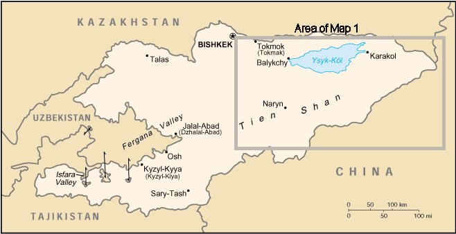
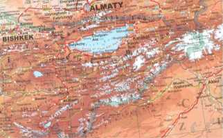
This area can be seen in Map 1, the area of white on the right of the map
includes the Central Tien Shan.
Terskei Ala-Too Range (Tien Shan)
The Terskei Ala-Too ranges stretches for 300km’s along the southern
coast of the Issyk-Kul. Its northern slopes include several large
gorges. The largest mountains are over 5,000m and the area contains
around 200 routes of varying degrees of difficulty. Routes tend to
be mixed rock and ice on walls up to 1,500m.
The climate is considerably milder than in Central Tien Shan, although
precipitation is higher (1600mm p/a). Most of the rain falls during
the beginning of summer but July and August are also characterised by
frequent snow and thunderstorms. The most stable weather is during
September.
The area can be reached by car and then base camps are reached within a days
walk.
This Area can be seen in Map 1. Lake Issyk-Kul is clearly visible and just
South of Bokonbaev is a thin line of mountains running east to west.
Kyrgyz Range (Tien Shan)
The Kyrgyz Range is just 40km from Bishkek and the highest summits are just
below 5,000m. Routes are typically rock and snow-ice, were the rock
consists of tough granite and granodiorite. Routes tend to be around
1,100metres in length.
The rainfall for this area is 690mm p/a, with the least amount of
rainfall in August and September.
Bishkek is the capital city of Kyrgyzstan and is clearly visible in all of the
maps in section Maps.
Western Kokshaal-Too Range (Tien Shan)
The Western Kokshaal-Too Range is located in the south of Kyrgyzstan
close to the China border. The highest summits here are just under
6,000 metres, 17 rise above 5,000m and 60 are above 4,000m. Most of
the summits in this area remain unclimbed including 11 above 5,000
metres. Walls are as high as 1,200m and routes can be up to 1,800m.
Routes are rock and/or snow-ice; the rock is either red or grey
granite and is supposed to be ideal for climbing.
The climate again is severe with the temperature rarely rising above 0C
even in the summer. Annual precipitation is 420mm p/a. Approaches
are 1-3 hours from the road.
From my conversations with the ITMC this is the area that I have been
recommended for a group of climbers with mixed ability wanting to do
new routes. The specific area recommended to me involved three
canyons east of the Ayatoly Glacier. I also have received some
estimates on the cost of an expedition to this area (see section Estimate from ITMC).
The Western Kokshaal-Too can be seen in Map 1. The range runs from the
Central Tien Shan (the large mass of mountains at the right of the
map) South West to the bottom centre of the map.
Akshiirak and Kuilyu Ranges (Tien Shan)
Located south east of the Issyk-Kul, half way between the lake and the
Chinese border. The weather here is very similar to that of the
Central Tien Shan, annual precipitation is 694mm p/a (most of which
falls during the summer). The highest mountains are just over 5,000
metres and cliffs are likely to be around 700 metres. Conditions are
considered to be excellent for ski mountaineering. Very few
expeditions have visited this area and there is lots of possibility
for the development of routes at all levels of difficulty.
Approach can again be made via car. No special permits are required for this
area.
This range is visible in Map 1 South East of lake Issyk-Kul, labelled
Ak-Shyyrak.
Zaalaiskii Range (Pamirs)
The alleged easiest summit over 7,000m is here, Peak Lenin. The routes
in this area are not technically difficult and consist mainly of snow
and ice. The climate is milder than in the Tien Shan, with an
average of 10C in July and August.
Turkestanskii Range (Pamirs)
This range’s northern faces look over Kyrgyzstan. As a whole little
of this region have been explored however the eastern and central
area of the northern faces should contain much to interest the
mountaineer. The climate is again milder than that of the Tien Shan,
with annual precipitation ranging from 250 – 400mm p/a
(increasing east to west).
The Lialiak and Karavshan Gorges are supposed to be paradise for
mountaineers. The rock resembles in structure to that of Patagonia
but differ with the amount available (a lot more) and the warmer
climate. The walls are 2000m high and the rock is granite, limestone
and sandstone. There is possibility to re-do technical routes and to
make new ascents. The area can be reached by car followed by 1 day
on foot/horse.
There are several other canyons and gorges to be explored, with plenty of new
routes to be made. Approaches can take 1-2 days on horseback.
Alaskii Range (Pamirs)
This range lies in South Kyrgyzstan separating the Fergana Valley from the
Alaiskii Valley. The climate is similar to that of the Turkestanskii
Range. The western and southern areas are the only areas of interest
to mountaineers. The highest peak in the area, Gandykul, is 5444
metres.
There is an abundance of rock with walls rising up to 1,500 metres high. The
rock is composed of solid limestone, sandstone and granitoides. In
the region of Kichik-Alai there are about 80 routes of varying
degrees of difficulty. The region is popular due to the easy
approach via Osh Town. There is a vast opportunity for putting up
new routes in this area. Arrival is possible via car followed by 1-2
days walk/horse ride.
Maps
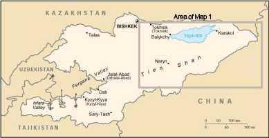
Map 1 - Western Area of Kyrgyzstan
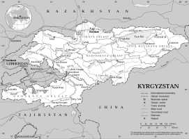
Map 2 - Kyrgyzstan Showing Major Areas
Map 3 - Kyrgyzstan Showing Major Roads and Cities
Further Details of Foreign Office Advice
Several detailed political protests in South of country
Mugging and theft reported in both cities and rural areas (usual foreign office recommendations reply)
Service stations limited outside cities
Tuberculosis is endemic throughout country.
Ensure helicopter evacuation insurance is gained before entering mountains
Travellers cheques not normally excepted, take enough money for journey
Recommended to register with Embassy if staying for prolonged periods of time or travelling off the beaten track
Penalties for possession of drugs can be severe
Cost Estimate from ITMC
Based on Pat Littlejohn’s expedition in 2001.
Transport
Airport – Bishkek: $35 per transfer
Bishkek – Base camp (including horses etc) $856 per transfer
Accommodation
Bishkek $15 - $70 (depending on standard required)
Food
$6 per day
per person ($15 for fresh meat)
Staff
Porters $18 - $23 per day per person, one person carries 15KG (incl. meals)
Cook $18 per day (incl. meals)
Some additions to these estimates for stays in cities.
Equipment
Tents $3 per tent per day
Long distance radio station $5 per day
Formalities
Visa Support $10 per person
Registration in passport department $10 per person
Border permit $10 per person
Known Expeditions in the Kyrgyzstan
Western Kokshaal-Too
Pat Littlejohn, Western Kokshaal-Too: Ayatoly Glacier. 2001
Anglo-American Western Kokshaal-Too: First British ascents in Ala Archa region,
followed by exploration of Kokshaal-Too range on the Chinese border.
Aug/Sept 1997
Central Tien Shan
Anglo-Welsh Tien Shan: Inylchek Glaciers June-Aug 1995
Bath University: Inylchek Glacier June/Sept 1990
British Tien Shan: Inylchek Glacier 1993
British Ukrainian Tien Shan: Inylchek Glacier Jul/Aug 1994
Chupi Orco: Komsomolets Glacier 1995
UK NZ Central Tien Shan: Inylchek Glacier. Jul/Aug 1991
Welsh/Scottish Tien Shan: Inylchek Glacier. Jul/Aug 1993.
Ak Cy Valley
Unknown: 1990
British Admiral Peak: Jul/Aug 1994
Unspecified/Other Areas
British Tien Shan: First Ascent of Pk5784 after failed attempt at first
ascent of Kirov Peak due to length of route. Aug/Sept 1995
European Tien Shan Expedition: Ascents of 4000m+ peaks and exploration of
area for future reference. Jul/Aug 1995
Kaingdy: Jul/Aug 1995
Kaxakh Apogee 2000: Exploration and climbing of rarely visited area.
Production of GIS and satellite image maps ongoing. Jul/Aug 2000
Saga Magazine Tien Shan: Bogda Ola Range. Jul/Aug 1995
Reading List

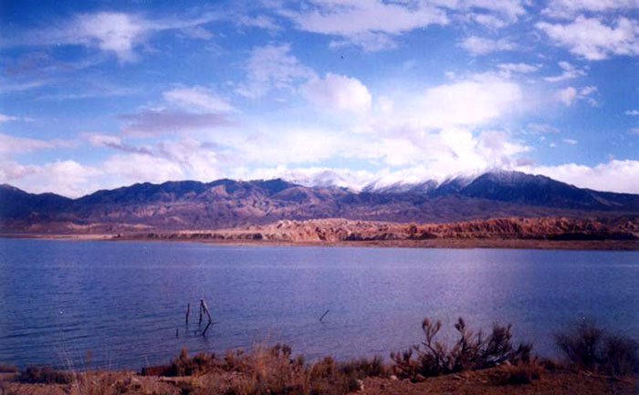
Image 2 - Issyk-Kul
Copyright © 2003 Karabiner Mountaineering Club
|