Sun 25th Jan, 2004
South Pennines Walk
Members: Jim Gregson, Sandy Gregson, Bob Haynes, Martin Heaton, Alan "Hyde" Jones, Lorna Marsland, Iain McCallum, Alan Peck, Brian Taylor, Frank Williams, Margaret Williams, Dave Wylie.
Guests: Karin Loffler, Nigel Officer, Annie Redhead, Helen Stephenson, "Skip" (Alan Jones' Dog)
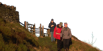
The view over the South Pennine moors was obscured by cloud first thing in the morning. However, by the time I had walked the two miles from home to the start of the meet at Watergrove, the cloud base was already noticeably higher. Vague worries that nobody would want to come out for a walk in the mist were soon dispelled by the eleven members (plus one dog), three prospective members and one ex-member (Helen) who congregated in the car park. The longer-serving KMC members were delighted to renew their acquaintance with Helen, who had not been around the KMC for several years.
At the appointed time, we set off along a slightly modified route. The original course, planned from the map, had proved to be rather poor going when tried for real on a reconnaissance mission. A more obvious, if slightly longer, track was followed instead. A re-grouping was required at Turn Slack Clough, after a trio had popped back to the car-park to retrieve the map that Frank had left behind. A cunning route across the moors led us up into mist which persisted all the way over to Reddyshore Scout, when at last the cloud started to lift.
The going underfoot was quite heavy, with some of the tracks incredibly muddy, thanks to the rain over the preceding days. This meant that we were slipping behind schedule as we wove our way Northwards. Frank and Margaret decided to cut the day short and snuck off before lunch, to take a shorter route back to the car. A brief shower passed over and then a beautiful rainbow signalled the end of the dull conditions, just before we reached our lunch spot.
Lunch was held at the Astronomy Centre http://www.astronomycentre.org.uk. Many KMC members will know that astronomy is one of my other hobbies (or, in more practical terms: when I haven't been busy working on Ty-Powdwr I've been helping build the observatory!). Many thanks to Peter Drew, who runs the Centre, for letting us stop by and eat our lunch amidst all the telescopes under the dome. Peter had also set up the Coronado Solar Telescope so that we could have a look at the spectacular solar prominences and details on the sun's surface. Another KMC member, Steve Taylor, plus his family (Lizzy, William and Jonathan) were also up at the Observatory. However, as they didn't actually do any of the walk, they don't get a meet tick!
The return leg of the walk was more direct and, with the paths in generally better condition than the outbound route, we made good time getting back to Watergrove. My offer of a cuppa (and apple pie!) back at my house was taken up by Jim, Sandy, Brian, Karin and Annie. This meant that I didn't have to walk home (thanks for the lift, Brian).
I hope everybody enjoyed the walk - I certainly did - thanks for coming along.
Dave Wylie
Meet Promo:
This will be another of my "local" walks, joining up sections of some of the many paths and tracks in my South Pennine stamping ground. I've tried to avoid making the walk too long, as daylight is in fairly short supply at this time of year. If all goes to plan, then the lunch stop will be at an indoor location that may be of nocturnal interest to a fair number of Club members (no, it's not a pub!). You should be able to work out what this place is by using the information below and the recommended OS 1:25000 Outdoor Leisure (no. 21) "South Pennines" map!
Meet at the car park at Watergrove Reservoir (Grid Reference SD 911 176) above Wardle, at 9:45am for a 10am start.
Proposed Route:
Watergrove Car Park - East Side of Reservoir - onto Rochdale Way - Dobbin Hill - Turn Slack Clough - Allenden Hill - Reddyshore Scout. Join the Todmorden Centerary Way to head North - Higher and Lower Allescholes - White Slack - Cranberry Dam - Ragby Bridge - Foul Clough Road - Gorpley Reservoir - Midgelden Bank. New path through Midgelden Pasture - cross A681 - lunch stop.
After Lunch, follow A681 up to Holden Gate - Limers Gate - trig point on Trough Edge End. Tracks to Ramsden Clough Reservoir - "stepping stones" - round Rough Hill - Ramsden Road - Watergrove.
The walk is about 13 or 14 miles, though there are several options to shorten the walk or even to add a bit on near the end if the day is fine and the company fit!
Anybody who is in need of a cuppa following the day's exertions will be welcome to come back to my house for one. Let's hope my Kettle works this time, unlike after last year's walk!
If you want any more information call me, e-mail me or see me in the pub. Note that on the Thursday immediately before this meet there is a KMC Winter Lecture, so I'll be at the Britons Protection rather than the Crown and Anchor.
Dave Wylie


